|
I thought that I'd start this section on glaciation with a look at how glaciers form in case, like me, the students haven't studied glaciers before. An icy worldThe Earth goes through cycles of ice ages, cold periods which last for millions of years. During these ice ages, there are cooler glacial periods and warmer interglacial periods. The last glacial period began about 100,000 years ago and ended about 10,000 years ago. Around 20,000 years ago over 30% of the land on Earth was covered by ice, including almost all of the UK. Ice sheets in the UK were up to 3 miles thick and one reached as far south as London. Today, we're in an interglacial period and only 10% of the Earth's land surface is covered by ice. How do we know about these past changes in temperature? There are three types of evidence for the changes: chemical evidence from the changing chemical composition of ice and marine sediments, from fossil remains showing the adaptations of the organisms to the past climate and, importantly for geographers, from the landforms that were created by glaciers. How are glaciers formed? The "Sea of Ice" of the glacier in the Valley Blanche, Chamonix, France © Heather Simpson The "Sea of Ice" of the glacier in the Valley Blanche, Chamonix, France © Heather Simpson Glaciers are often described as rivers of ice (see photo right). They move downhill and are so powerful that they carve valleys out of mountains.
Glaciers form when multiple snowfalls in mountainous or polar regions fill valleys and sheltered hollows. Summer temperatures are important, as this snow must remain on the ground year round in order for glaciers to form. As these successive layers are compacted by further snowfall on top, they turn into ice. This process is demonstrated in this BBC video How glaciers form. This section of the glacier where the snow accumulates is called the zone of accumulation. As the snow and ice continue to pile up, the lower layers get pushed downwards under the force of gravity to the section of the glacier where less snow falls and where the ice melts to form meltwater. This part of the glacier is known as the zone of ablation. As it travels, the glacier transports this ice along, and in doing so erodes the landscape and picks up, transports and deposits material, creating the landforms that I'll look at in detail in the next few posts. The glacier is constantly transporting the ice from the upper part of glacier where it fell and moving it forward along the glacier, so even when the glacier as a whole is getting smaller and retreating, the ice is still being transported along. Whether a glacier advances or retreats depends on the difference between inputs and outputs of the glaciers. The difference between the accumulation (snow and ice) and ablation (ice melting) for one year is known as the glacial budget. If more snow forms and ice forms than the amount of ice that melts, there is a positive glacial budget and the glacier advances. However, if more ice melts than is formed in the zone of accumulation, there is a negative glacial budget and the glacier gets smaller and retreats up the valley. There is evidence that the world's remaining glaciers, in places such as Greenland, Antarctica and Europe, are shrinking and some are in danger of disappearing. The main cause of this is global warming as average global temperatures have increased by about 0.9°C in the last 150 years. Sources: BBC (2015) 'Glaciers' BBC Science. [Accessed on 19/08/15] Available from: http://www.bbc.co.uk/science/earth/water_and_ice/glacier British Geological Society (2015) 'Ice and our landscape' Geology of Britain. [Accessed on 19/08/15] Available from: http://www.bgs.ac.uk/discoveringGeology/geologyOfBritain/iceAge/home.html?src=topNav Coordination Group Publications Ltd. (2010) GCSE Geography: The Revision Guide. CGP. Royal Geographical Society (no date) 'Glaciation and geological timescales - Not an ice cube: how glaciers work' Teaching resources: Key stage 3 resources. [Accessed 19/008/15] Available from: http://www.rgs.org/OurWork/Schools/Teaching+resources/Key+Stage+3+resources/Glaciation+and+geological+timescales/Not+an+ice+cube+-+how+glaciers+work.htm
0 Comments
Glaciers transport and deposit materialAs I looked at in the previous post, glaciers erode rock, creating distinctive landforms. This eroded material is then transported and deposited by the glacier, forming different landforms. A glacier works like a conveyor belt, constantly transporting material downhill. The ice continues to move downhill, even when the zone of ablution at the bottom of the glacier is receding. The material can be frozen inside the glacier, carried on its surface or bulldozed, which means material is pushed in front of the glacier. Material can include rock, gravel, sand and clay, but even ancient human remains have been found transported in glaciers. Deposition occurs when the ice melts at the snout (or end) of the glacier, which is why this part of the glacier, the zone of ablution, often looks grey and dirty, or if the ice is overloaded with material. Glacial deposits are deposited when the ice melts, and unlike river deposits which are sorted by weight, glacial deposits can be rocks of all shapes and sizes, from fine clay to rocks the size of a house. Fluvo-glacial deposits are washed out of the ice by meltwater, and these are sorted by weight, with heavier materials deposited first. Landforms produced by transportation and depositionMoraines These are piles formed from material deposited by the glacier as it melts. There are four different types depending on their position.
Drumlins Elongated hills of glacial deposits. They can be 1km long and 500m wide, and often occur in groups. They are formed from the debris carried along and then accumulated under a glacier, which was deposited when the ice became overloaded with sediment. One end is round, blunt and steep and the other tapered, pointed and gently sloping, showing the direction the glacier moved in. There is still disagreement among glaciologists as to how exactly drumlins were formed. Erratics As I said, glacial deposits come in a mix all shapes and sizes. Extremely big deposits are called erratics. They are large rocks or boulders and are often found on their own. They are often unusual shapes and a rock type which is uncommon in the area they were deposited in. This video from the BBC gives more information about and examples of erratics: Erratics in Switzerland Till Till is a poorly sorted mix of mud, sand and gravel-sized material deposited directly by glacier ice. Outwash plain A flat spread of sediment deposited by meltwater streams from a glacier. Photo examples of these landforms are shown in the slideshow below. Sources:
Coordination Group Publications LTd. (CGP) (2010) GCSE Geography: The Revision Guide. CGP. Royal Geographical Society (no date) 'How glaciers shape the land and what they leave behind' Teaching resources: KS3 teaching resources. [Accessed on 24/08/15] Available from: http://www.rgs.org/OurWork/Schools/Teaching+resources/Key+Stage+3+resources/Glaciation+and+geological+timescales/How+glaciers+shape+the+land+and+what+they+leave+behind.htm BBC (2014) 'Landscapes of glacial deposition' Geography: Glaciation. [Accessed on 24/08/15] Available from: http://www.bbc.co.uk/bitesize/standard/geography/glaciation/glacial_deposition/revision/4/ Although the main focus of the exam specifications is the current glaciated landscapes of the UK, the specifications do refer to the processes of erosion, transport and deposition that once took place in the UK. GCSE students should understand different types of erosion from previous geography topics such as rivers and coasts, but may not have studied them in the context of glaciers. How glaciers erode the landscapeAlthough glaciers move extremely slowly, they are incredibly powerful and have a huge effect on the landscape. One of the processes that it caused by the advance of a glacier is erosion. Note that 'weathering refers to the weakening and breakdown of rock in its position (without being moved); whereas erosion refers to the picking up and removal of the weathered rock, thereby wearing away the land' (Royal Geographical Society, no date) The weight of the ice in the glacier causes it to move downhill, and as it does it erodes the landscape in two main ways:
Then as the glacier moves, it rips out the pieces of rock.
of the glacier and wear it away, like sandpaper. The rock above glaciers is also weathered by freeze-thaw weathering. This is when water gets into cracks in rocks and freezes, causing the rock to expand and putting pressure on it. When it then thaws, the pressure is released. Repeated freezing and thawing widens cracks and causes parts of rock to fall off. At the top of the glacier, in the zone of accumulation, the ice doesn't move in a straighten line. Instead it turns in a circular motion called rotational slip. This erodes hollows and deepens them into bowl shapes. Landforms produced by glacial erosion
the valleys and forming a sharp edge between them.
eroding the mountain.
Formed by a hollow containing a small glacier which is eroded by rotational slip. It often contains a tarn - a small circular lake formed when the glacier melts.
eroded by a river are cut off as the glacier moves past, leaving truncated spurs.
tributary glaciers (similar to a river's tributaries) flow into the main glacier, but the glacial trough is eroded much more deeply by the larger glacier so when the glaciers melt the hanging valleys are left "hanging" at a higher level.
resistant rock was eroded more than the surrounding hard rock.
moutonnee can result. It often has a steep, jagged face as a result of plucking on the far side, and a gradual incline on the other side which is smoothed and polished by abrasion. Striations on the rock indicate the direction the glacier moved in. Examples of all these glaciated landforms in the UK can be seen in the slideshow below. Sources:
BBC (2014) 'Landscapes of glacial erosion' BBC Bitesize Geography: Glaciation. [Accessed 20/08/15] Available from: http://www.bbc.co.uk/bitesize/standard/geography/glaciation/glacial_erosion/revision/1/ Coordination Group Publications Ltd. (CGP) (2010) GCSE Geography: The Revision Guide. CGP Glaciers online (2015) Photoglossary: Alphabetic list. [Accessed on 20/08/15] Available from: http://www.swisseduc.ch/glaciers/glossary/ Royal Geographical Society (no date) 'Glaciation and geological timescales - How glaciers shape the land and what they leave behind.' Teaching resources: KS3 teaching resources. [Accessed on 20/08/15] Available from: http://www.rgs.org/OurWork/Schools/Teaching+resources/Key+Stage+3+resources/Glaciation+and+geological+timescales/How+glaciers+shape+the+land+and+what+they+leave+behind.htm  Ivinghoe Beacon in the Chiltern Hills By Pointillist (Own work) [CC BY-SA 3.0 (http://creativecommons.org/licenses/by-sa/3.0) or GFDL (http://www.gnu.org/copyleft/fdl.html)], via Wikimedia Commons  A simplified geological diagram of the Wealden Dome as relating to Kent By ClemRutter (self-made using Inkscape) CC-BY-SA-3.0 or CC BY-SA 2.5 via Wikimedia Commons https://commons.wikimedia.org/wiki/File:KentGeologyWealdenDomeSimple.svg A simplified geological diagram of the Wealden Dome as relating to Kent By ClemRutter (self-made using Inkscape) CC-BY-SA-3.0 or CC BY-SA 2.5 via Wikimedia Commons https://commons.wikimedia.org/wiki/File:KentGeologyWealdenDomeSimple.svg Characteristics of chalk and clay landscapes
Chalk and clay is mainly found in the south east and east of England in lowland areas. Horizontal layers of chalk and clay sometimes tilt diagonally, due to tectonic activity. Clay is less resistant than chalk so it is eroded faster, leaving chalk sticking out to form escarpments and wide flat areas where the clay was eroded called vales. Escarpments have steep scarp slopes on one side, and gentle dip slopes on the other. This pattern of vales and escarpments can be seen in this diagram of The Weald in south east England. Chalk is a permeable rock that stores water, known as an aquifer. Clay is impermeable. Water flows through the chalk and surfaces where it meets an impermeable rock. Where the water emerges is called a spring line. Chalk areas also feature dry valleys, which were formed during the Ice Age when the ground was frozen and impermeable, but today the water flows underground beneath the valley. Uses of chalk and clay landscapes Chalk is quarried to use in cement for the building industry. Tourists are attracted to the scenery and enjoy activities such as hiking. The wide, flat vales are suitable for arable farming, livestock rearing and dairy farming. As chalk is an aquifer, it is used to supply drinking water using wells and pumps. Sources: Coordination Group Publishing Ltd. (CGP) (2010) GCSE Geography: The Revision Guide. CGP.  Andy Mabbett [CC BY-SA 3.0 (http://creativecommons.org/licenses/by-sa/3.0)], via Wikimedia Commons https://commons.wikimedia.org/wiki/File:Treak_Cliff_Cavern_-_interior_-_Andy_Mabbett_-_38.JPG Andy Mabbett [CC BY-SA 3.0 (http://creativecommons.org/licenses/by-sa/3.0)], via Wikimedia Commons https://commons.wikimedia.org/wiki/File:Treak_Cliff_Cavern_-_interior_-_Andy_Mabbett_-_38.JPG Characteristics of carboniferous limestone landscapes Limestone is formed of calcium carbonate from the remains of sea creatures and corals on the seabed. There are different types of limestone in the UK:
As the weak carbonic acid in rainwater slowly dissolves carboniferous limestone via chemical weathering, especially as it is a pervious rock which means water flow is restricted to the bedding planes and joints, making them more vulnerable to weathering. At the surface: Limestone pavements are flat areas of limestone blocks called clints, which are separated by weathered joints called grikes. Swallow holes are weaknesses in the rock that have been weathered to form holes. Limestone gorges are steep sided gorges which are formed when a cavern underground collapses. Dry valleys are formed when a river which used to flow on the surface (due to the ground being frozen during an Ice Age or due to a higher water table) now flows underground. Resurgent rivers are rivers that emerge to the surface when the limestone is on top of impermeable rock. This BBC Bitesize video shows these processes: http://www.bbc.co.uk/education/clips/z3jfb9q Underground: Caverns form when water flows through joints in the rock or down swallow holes. Stalactites and stalagmites form in caverns when the dissolved minerals in the water solidify and build up. When they meet they form a pillar and when it flows as a sheet, a curtain builds up. This BBC Bitesize video demonstrates these processes: http://www.bbc.co.uk/education/clips/zjs8q6f Uses of carboniferous limestone landscapes Limestone is quarried for building stone and also used to make cement. Tourists visit limestone landscapes to see the distinctive features, such in the Yorkshire Dales, a case study which I'll look at in more detail in the Teaching Ideas section. Dairy farming and rearing livestock is common in limestone areas, as well as some arable farming, although the soil can be too alkaline. Sources: BBC (no date) Bitesize: GCSE Geography. Rock Landscapes Classroom Resources. [Accessed on 11/08/15) Available from: http://www.bbc.co.uk/education/topics/ztbd7ty/resources/3 Coordination Group Publications Ltd. (CGP) (2010) GCSE Geography: The Revision Guide. CGP.Waugh, D. and Bushell, T (2002) New Key Geaography for GCSE. Nelson Thrones, Cheltenham. p.52  Saddle Tor, Dartmoor By Herby Thyme (Own work) CC BY-SA 3.0 (http://creativecommons.org/licenses/by-sa/3.0)], via Wikimedia Commons From https://commons.wikimedia.org/wiki/File:Saddle_tor_evening.jpg Saddle Tor, Dartmoor By Herby Thyme (Own work) CC BY-SA 3.0 (http://creativecommons.org/licenses/by-sa/3.0)], via Wikimedia Commons From https://commons.wikimedia.org/wiki/File:Saddle_tor_evening.jpg Characteristics of granite landscapes
The main landforms found in granite areas are tors (see photograph of Saddle Tor, above) Over time the material above an area of granite is weathered and removed by rivers and glaciars. This reduces the pressure on the granite beneath, causing cracks called joints. Rock with joints close together are weathered and broken down more quickly than sections with fewer joints, meaning that they are weathered more slowly than surrounding rock. As the weathered material is removed over time, it leaves rocky outcrops sticking out of the surface. A more in-depth explanation can be found here. However, this is for A Level students, so a more simplified description should be sufficient for GCSE level. http://www.dartmoor.gov.uk/learningabout/lab-printableresources/lab-factsheetshome/lab-torformation Due to the impermeable rock and the high rainfall in many granite areas, the soil is waterlogged and acidic. This leads to moorlands, marches and bogs with low-growing vegetation, as can be seen in the photograph above. Deep, steep V-shaped valleys are also formed by streams eroding cracks in the rock. Uses of granite landscapes Granite is quarried and used as building stone. For example, Aberdeen is known as the Granite City due to the amount of granite used in building construction. Granite areas have poor soils unsuitable for arable farming or dairy farming, but they can be suitable for rearing livestock. The impermeable rock makes granite areas suitable for reservoirs. The unique landscapes of granite areas also attract tourists, as we will look at in more detail in the Dartmoor case study, found in the Teaching Ideas section. Sources: S-Cool (2015) Rocks and landscapes: Granite. [Accessed on 11/08/15] Availablefrom: http://www.s-cool.co.uk/gcse/geography/rocks-and-landscapes/revise-it/granite Dartmoor National Park Authority Geology and Landforms 'Tor formations - Dartmoor Factsheet' [Accessed on 11/08/15] Available from: http://www.dartmoor.gov.uk/learningabout/lab-printableresources/lab-factsheetshome/lab-torformation Coordination Group Publications Ltd. (CGP) (2010) GCSE Geography: The Revision Guide. CGP Formation and characteristics of rock types The Rock Cycle The Geological Society of London (no date) The Rock Cycle (KS3). http://www.geolsoc.org.uk/ks3/gsl/education/resources/rockcycle.html The Rock Cycle The Geological Society of London (no date) The Rock Cycle (KS3). http://www.geolsoc.org.uk/ks3/gsl/education/resources/rockcycle.html Rocks are classified into three types depending on how they are formed. They are igneous, sedimentary and metamorphic. Igneous Igneous rocks are formed when magma from the mantle cools and hardens. If it cools underground, it is intrusive. This cools slowly and forms large crystals and a coarse texture. If it cools above ground after a volcanic eruption, it is extrusive. This cools quickly and forms fine crystals and a fine texture. Igneous rock can form a batholith, a dome of rock formed by large dome of magma cooling. Igneous rocks are tough and resistant to erosion. Example of igneous rocks in the UK are granite and basalt. Sedimentary As the name suggests, these rocks are formed when layers of sediment at the bottom of a sea or lake are compacted. This process is called lithification. The sediment comes from the shells and skeletons of dead sea creatures, as well as eroded material from rocks. Although some sedimentary rocks are tough, such as limestone, most are weaker than igneous and metamorphic rocks. Sedimentary rocks often contain fossils and UK examples include limestone, chalk, clay and shale. Metamorphic Metamorphic rocks are rocks that have “morphed” due to heat and pressure: Rocks deep in the Earth are changed by the pressure on them. Tectonic plate collisions create heat and pressure which changes the rocks. Heat from magma causes rocks to change The rock becomes harder and more compact after the change, so more resistant to erosion. For example, limestone becomes marble and clay becomes slate. The formation of all these rock types is linked by the rock cycle (see left). Distribution of rock types Geological map of the UK and Ireland. IPR/123-16CT British Geological Survey © NERC Geological map of the UK and Ireland. IPR/123-16CT British Geological Survey © NERC The map below shows the distribution and ages of rock across the UK. Here we can see the upland-lowland differences in geology. The lowland south and east is made up of much more recent sedimentary rocks, whereas as the upland areas in Scotland, Wales and northern England are dominated by older sedimentary rocks, and metamorphic and igneous rocks which are more resistant to erosion.
These different rock types have shaped the landscape of the UK not just through the physical features they form, but through the impact they have had on how humans use the land and how that in turn changes the landscape. Sources: The Geological Society. (no date) Rock Cycle Processes. [Accessed on 05/08/15] Available from: http://www.geolsoc.org.uk/ks3/gsl/education/resources/rockcycle/page3446.html Coordination Group Publications Ltd. (CGP) (2010) GCSE Geography: The Revision Guide. CGP. 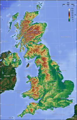 Photo by Captain Blood CC-BY-SA-3.0 via Wikimedia Commons https://en.wikipedia.org/wiki/ Geography_of_the_United_Kingdom Photo by Captain Blood CC-BY-SA-3.0 via Wikimedia Commons https://en.wikipedia.org/wiki/ Geography_of_the_United_Kingdom If I were starting this topic with a class, I’d start off with a lesson giving an overview of the topic and setting the context, before going into more detail in the next few lessons. So, I’d thought I’d start this blog in the same way. A landscape can be defined as 'all the visible features of an area of land, often considered in terms of their aestheic appeal' (www.oxforddictionaries.com). A landscape can be natural, man-made, or a combination of the two. In Geography we look at the physical and human processes that form these landscapes. The UK has a diverse range of landscapes for an island of its size, from mountains to moorland, woodland to rolling hills. This collection of photographs shows some of the varied and stunning scenery across the UK: http://www.countryfile.com/countryside/best-places-landscape-photography-uk These landscapes have been formed over millions of years by different geomorphic processes and more recently, human activity. Looking at this relief map of the UK on the right, we can see how varied the topography of the country is, and can divide it up into upland and lowland. Upland areas cover about a third of Great Britain and are mainly found in Scotland, Wales and northern England. They feature mountains, moors, heathland, bogs and woodland (see photo below left). The geology of upland areas is mainly old, hard igneous and metamorphic rocks. These rocks are not easily eroded so they form mountainous upland areas. The climate tends to be cooler and wetter in upland regions. Lowland areas feature grassland, heathland, wetlands such as bogs and fens, and woodland (see photo below right). The geology in lowland areas is mostly made up of younger sedimentary rocks. The climate in lowland areas is generally warmer and drier than upland areas.
 Photo by DAVID ILIFF. License: CC-BY-SA 3.0 https://en.wikipedia.org/wiki/Ar%C3%AAte Photo by DAVID ILIFF. License: CC-BY-SA 3.0 https://en.wikipedia.org/wiki/Ar%C3%AAte Several ice ages have carved out and shaped the land, leaving upland glaciated landscapes in some parts of the country. They have left distinctive features such as ribbon lakes, U-shaped valleys, layers of boulder clay and arêtes, such as this one in Snowdonia shown on the left. Past tectonic activity has also left its mark. This can be seen in the fault lines across Scotland, and the remains of the extinct volcano on which Edinburgh Castle is built. Humans have also shaped the landscape through agriculture, forestry and settlement. Tourism in certain areas of the country has also caused changes to the landscape, for example through footpath erosion in popular National Parks. All these various factors over millions of years have created the varied and distinctive landscapes of the UK today. Sources: Joint Natural Conservation Committee (2014) UK Habitat Types [Accessed on 02/08/15] Available from: jncc.defra.gov.uk/page-4532 Bowen, A. and Pallister, J. (2006) Understanding GCSE Geography. Heinemann. The Geological Society. The Rock Cycle: Glaciation in Britain. [Accessed on 03/08/15] Available from: http://www.geolsoc.org.uk/ks3/gsl/education/resources/rockcycle/page3585.html Averis, A., Averis, B., Birks, J., Horsfield, D., Thompson, D., & Yeo, M., (2004), An Illustrated Guide to British Upland Vegetation. [online] Pelagic Publishing, Exeter. [Accessed on 02/08/15] Available from: http://jncc.defra.gov.uk/PDF/British_Upland_Vegetation_(2014_reprint)Low_Res.pdf/ |


