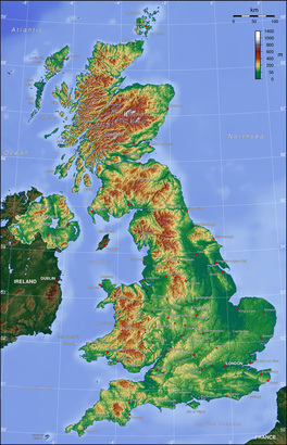
 Photo by Captain Blood CC-BY-SA-3.0 via Wikimedia Commons https://en.wikipedia.org/wiki/ Geography_of_the_United_Kingdom Photo by Captain Blood CC-BY-SA-3.0 via Wikimedia Commons https://en.wikipedia.org/wiki/ Geography_of_the_United_Kingdom If I were starting this topic with a class, I’d start off with a lesson giving an overview of the topic and setting the context, before going into more detail in the next few lessons. So, I’d thought I’d start this blog in the same way. A landscape can be defined as 'all the visible features of an area of land, often considered in terms of their aestheic appeal' (www.oxforddictionaries.com). A landscape can be natural, man-made, or a combination of the two. In Geography we look at the physical and human processes that form these landscapes. The UK has a diverse range of landscapes for an island of its size, from mountains to moorland, woodland to rolling hills. This collection of photographs shows some of the varied and stunning scenery across the UK: http://www.countryfile.com/countryside/best-places-landscape-photography-uk These landscapes have been formed over millions of years by different geomorphic processes and more recently, human activity. Looking at this relief map of the UK on the right, we can see how varied the topography of the country is, and can divide it up into upland and lowland. Upland areas cover about a third of Great Britain and are mainly found in Scotland, Wales and northern England. They feature mountains, moors, heathland, bogs and woodland (see photo below left). The geology of upland areas is mainly old, hard igneous and metamorphic rocks. These rocks are not easily eroded so they form mountainous upland areas. The climate tends to be cooler and wetter in upland regions. Lowland areas feature grassland, heathland, wetlands such as bogs and fens, and woodland (see photo below right). The geology in lowland areas is mostly made up of younger sedimentary rocks. The climate in lowland areas is generally warmer and drier than upland areas.
 Photo by DAVID ILIFF. License: CC-BY-SA 3.0 https://en.wikipedia.org/wiki/Ar%C3%AAte Photo by DAVID ILIFF. License: CC-BY-SA 3.0 https://en.wikipedia.org/wiki/Ar%C3%AAte Several ice ages have carved out and shaped the land, leaving upland glaciated landscapes in some parts of the country. They have left distinctive features such as ribbon lakes, U-shaped valleys, layers of boulder clay and arêtes, such as this one in Snowdonia shown on the left. Past tectonic activity has also left its mark. This can be seen in the fault lines across Scotland, and the remains of the extinct volcano on which Edinburgh Castle is built. Humans have also shaped the landscape through agriculture, forestry and settlement. Tourism in certain areas of the country has also caused changes to the landscape, for example through footpath erosion in popular National Parks. All these various factors over millions of years have created the varied and distinctive landscapes of the UK today. Sources: Joint Natural Conservation Committee (2014) UK Habitat Types [Accessed on 02/08/15] Available from: jncc.defra.gov.uk/page-4532 Bowen, A. and Pallister, J. (2006) Understanding GCSE Geography. Heinemann. The Geological Society. The Rock Cycle: Glaciation in Britain. [Accessed on 03/08/15] Available from: http://www.geolsoc.org.uk/ks3/gsl/education/resources/rockcycle/page3585.html Averis, A., Averis, B., Birks, J., Horsfield, D., Thompson, D., & Yeo, M., (2004), An Illustrated Guide to British Upland Vegetation. [online] Pelagic Publishing, Exeter. [Accessed on 02/08/15] Available from: http://jncc.defra.gov.uk/PDF/British_Upland_Vegetation_(2014_reprint)Low_Res.pdf/
1 Comment
|


