|
Starter To get students thinking, show a photo of a glaciated landscape and ask them to guess how the landscape was shaped. Or, this Landscape image interpretation task powerpoint presentation from the Royal Geographical Society's lesson plan How glaciers shape the land and what they leave behind is a really good way to get students thinking about the landforms. The PPT covers landforms formed by erosion and deposition, so it could be adapted if the two processes were being covered in separate lessons. I would clarify to students that a glacial landscape is one which is still has a glacier, whereas a glaciated landscape once had glaciers but they no longer exist, only the landforms that they created are left. Main activities I would make sure students remember the difference between weathering (break down of rock in situ) and erosion (removal of rock). Students watch this BBC video Highland landforms - before and after glaciation, which clearly demonstrates the effect of the glacier on the landscape. Now students understand the impact of glaciers on the landscape, ask them if they remember any different types of weathering and how these might be used in a glacier. This video has a nice visual of how abrasion and plucking work, so I would just show that brief clip from the video. Students could then use the Glaciers online photoglossary, available here, to write a brief explanation or description for each of the formations. They could then label blank diagrams based on these examples on the BBC Bitesize page Landscapes of glacial erosion on an OS map or the diagram below, taken from this video. Students could then be assigned a feature to work on individually or in a group and produce a poster with a description of the feature, an explanation of how it was formed, a photograph of a named located example and a sketch of the feature. To differentiate the task, some students could be given key words that they have to include and the teacher can bear the students' abilities in mind when assigning features. 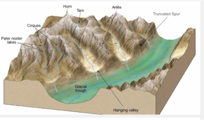 Plenary
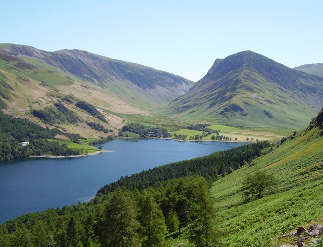
Put up a photo of a glaciated area of the UK, e.g. Highlands, Snowdonia, Lake District. Ask students how we can tell that there used to be glaciers there. Or a quick quiz using a slideshow of example photos, students work in groups to name the feature and get points for each correct answer. For an example selection of photos, see the subject knowledge page for this topic. Homework/Project Students could build a 3D model of a specific erosional feature or of a wider glaciated landscape, for example out of plasticine. These BBC bitesize videos are also very useful: Lochaber - High level glaciated landscape - http://www.bbc.co.uk/education/clips/zf46n39 Lochaber - Glaciated valley landscape - http://www.bbc.co.uk/education/clips/zrqygk7
0 Comments
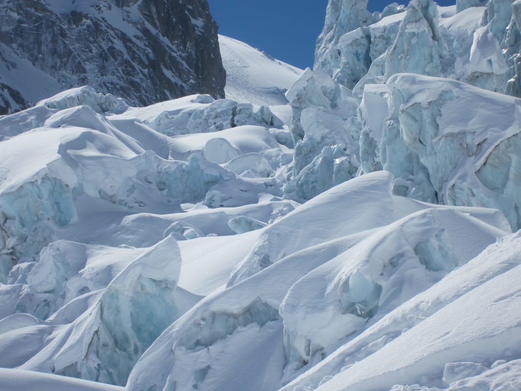
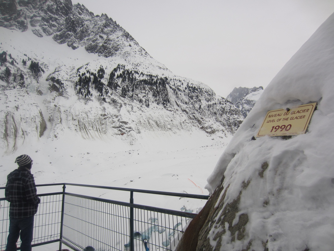
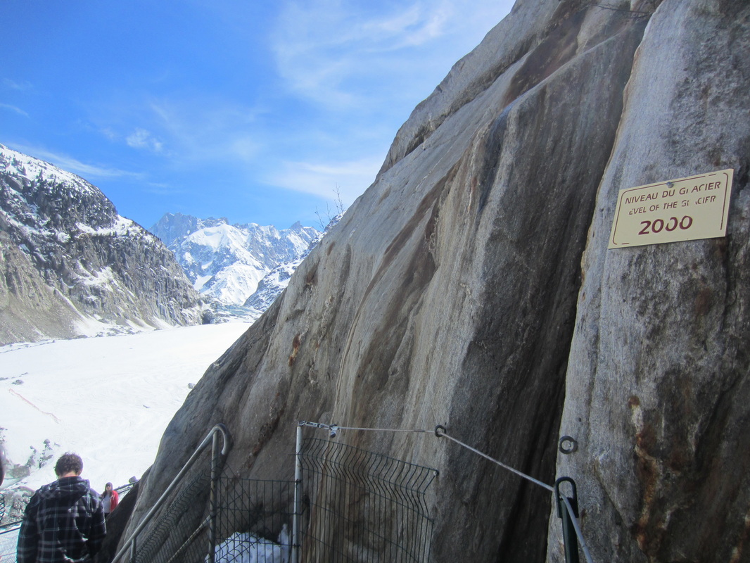
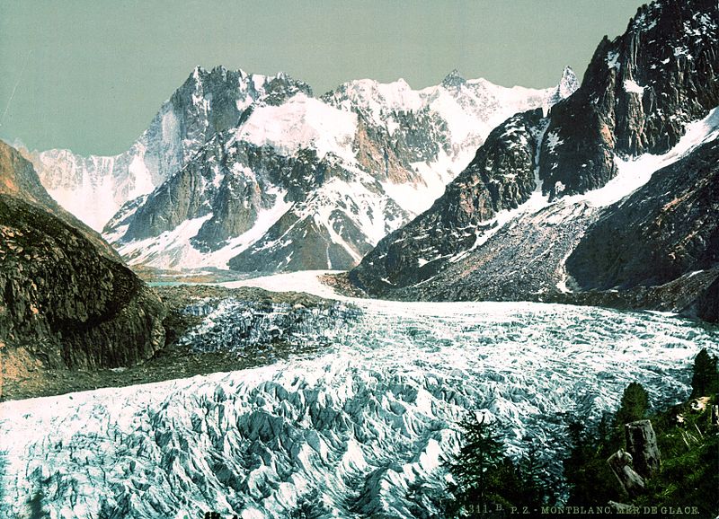
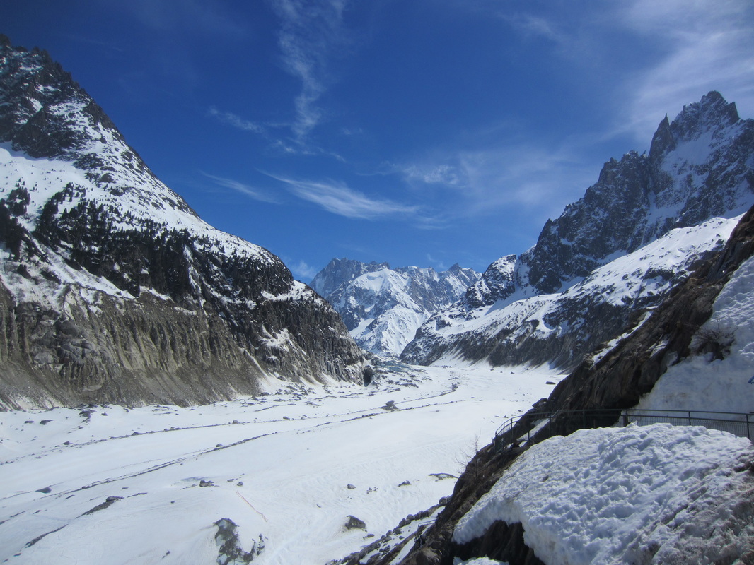
I would start the topic with a lesson to set the context, introduce the topic and check what students already know about glaciers. Starter To get students quiet and thinking about the topic, I would put this riddle on the board and give them a few minutes to discuss what the answer could be: I cove 10% of the Earth's land, sometimes 2 miles thick. And I'm also in your Coke when you take a sip. I so heavy I cause dents in the surface here and there. Yet I started life as a snowflake, light as air. The answer is ice. Then I would ask students to guess the topic of glaciers using clues. These could be photos such as those below, as well as the sound of a creaking moving glacier playing in this BBC video playing in the background. As a class we create a mindmap of what they already know about glaciers. Main activities I would start by asking students when they think the last ice age was, how cold it was in the UK then and if they could survive it? The answer is that technically we are living in an ice age now! It's called the Pliocene-Quaternary glaciation and started about 2.58 million years ago. It's just that we're living in a warmer period of an ice age called an interglacial period. What we usually think of as an ice age is a cooler period called a glacial period and the last one ended 10,000 years ago. Ask students where we can find glaciers in the world? (Antarctica, Himalayas, Switzerland, Greenland, Iceland, Norway, New Zealand, USA, Canada are just a few examples, a full list can be found on wikipedia.) Atlases could be used for this stage. Photos of these glaciers could be shown so students understand what a glacier looks like. Ask students if there are any glaciers in the UK? (No) Were there any in the past? (Yes) How do we know that? (the landscapes that they formed can still be seen today) Having looked at the location of current day glaciers, ask students what conditions are needed for glaciers to form? (year round low temperatures, snow fall) Students then watch the BBC video The formation, flow and retreat of glaciers. While watching students take notes and after label a diagram. Alternatively, we could brainstorm words to describe the formation, flow and appearance of glaciers, before students write a paragraph describing the process. For weaker students they could do a gap fill instead or use a writing frame. Although glacial budgets isn't part of the specifications for AQA or Edexcel A, the two exam boards which cover glaciation, I would check students' understanding. I would show them my photos from the Mer de Glace glacier in Chamonix-Mont-Blanc in France showing the rapid change in the size of the glacier. I would ask them what they think caused this. To clarify, I would ask what happens when more snow falls at the top of a glacier than melts at the bottom? (positive glacial budget, glacier advances)
What if less snow falls and more snow melts? (negative glacial budget, glacier retreats and shrinks) Are most of the world's glaciers advancing or retreating? (retreating) Why do you think that is? (global warming) Plenary Students write definitions for some of the key words from the lesson, such as glacier, retreat, advance, glacial period, interglacial period. Homework Students could research a current day glacier, with info such as location, size, age, movement, human uses. This lesson looks at chalk landscapes using the case study of the South Downs. Case study: The South Downs Location of the South Downs National Park Contains Ordnance Survey data © Crown copyright and database right [CC BY-SA 3.0 (http://creativecommons.org/licenses/by-sa/3.0)], via Wikimedia Commons Location of the South Downs National Park Contains Ordnance Survey data © Crown copyright and database right [CC BY-SA 3.0 (http://creativecommons.org/licenses/by-sa/3.0)], via Wikimedia Commons Characteristics
which is 271 metres above sea level - white cliffs, such as Beachy Head, where the chalk escarpment meets the coast - smooth, rolling hills - dry valleys Human activity
Human impacts on the landscape
Sources: BBC (2014) 'Case study: Chalk in the South Downs' BBC Bitesize Geography: Rock types in the British Isles. [Accessed 17/08/15] Available from: http://www.bbc.co.uk/schools/gcsebitesize/geography/rock_landscapes/rock_types_rev3.shtml Wikipedia (2015) South Downs. [Accessed on 17/08/15] Available from: https://en.wikipedia.org/wiki/South_Downs The 'South Downs Integrated Landscape Character Assessment: Technical Report' (Land Use Consultants, 2005) is a very interesting and useful resource for both broader and more in-depth information on the South Downs. Starter Show a selection of photos of chalk landscapes e.g. Uffington White Horse, The Seven Sisters in East Sussex, photo of the South Downs showing white chalk footpaths. Give students a few minutes to work out what the connection is - they're all chalk landscapes. Main activities Students read this info sheet The Geology of Portsdown Hill and study the cross section diagram below of the geology of Portsdown. Ask them to answer the following questions after reading:
NOTE: Portsdown Hill is not part of the South Downs, but these resources were excellent at demonstrating chalk formations.  Cross section of the geology of Portsdown Hill Friends of Portsdown Hill (no date) 'History' Friends of Portsdown Hill. http://www.portsdown.hampshire.org.uk/history.htm The students then link this knowledge of chalk landscapes to specific examples in the South Downs by matching photos or diagrams of the following features to a description of their formation.
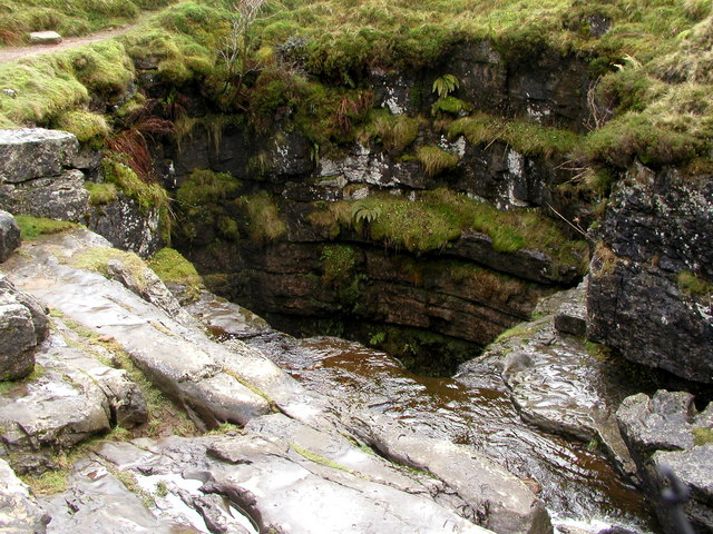
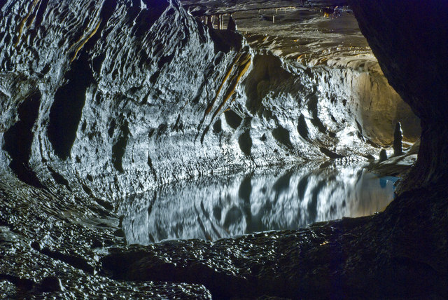
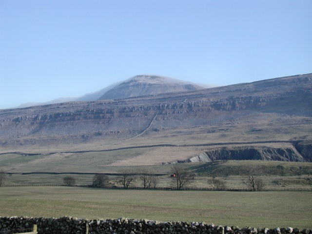
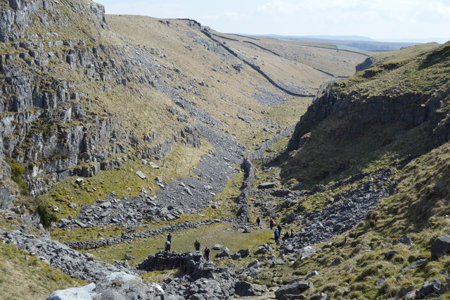
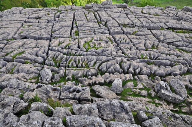
Students could then label a diagram similar to the one shown on the S-cool website's page on Chalk and Clay. Finally, students brainstorm human uses of the South Downs and the teacher introduces any they missed. Students then think about which of these activities change the landscape and to what extent. For the more difficult ones, like the grazing and WW2 farming, photos could be shown as clues. Plenary Tell students that the South Downs have been the inspiration for several authors, poets and artists. Show the students the following quotes and ask them to write their own one line poetic description of the South Downs. Put a selection of photos up on the board to give them some inspiration. Listen to a few examples from the class. Algernon Charles Swinburne "the green smooth-swelling unending downs" Rudyard Kipling "blunt, bow-headed, whale-backed downs" William Henry Hudson "during the whole fifty-three mile length from Beachy Head to Harting the ground never rises above the height of 850 feet, but we feel on top of the world." I would first start with a general lesson introducing carboniferous limestone landscapes, then do a case study on the landscape of the Yorkshire Dales. Starter Tell your partner three facts about limestone e.g. formation, what it's made from, examples, distribution in UK. Review some answers and establish that students know that limestone is formed mainly of calcium carbonate, which comes from the remains of coral and sea shells and was formed on the seabed. We'll look at one particular type of limestone called carboniferous limestone. This creates distinctive landscapes because it is susceptible to chemical weathering from the weak acids in rainwater, it is laid down in layers called bedding planes and has vertical joints and these weaknesses are vulnerable to weathering and finally because it is a permeable pervious rock which means that water can flow through these joints and bedding planes. Main activities Surface features Students are given photos of limestone features and descriptions, such as this activity on the BBC Education Scotland site 'Upland Limestone: Surface features'. With a partner they match them up. Students then write a brief description of the landform, possibly on a worksheet with photos or diagrams of the features. Ask students what they think happens to the water when it flows down a sinkhole or under a dry valley, what did a resurgent stream look like before it reached the surface. Underground features Students are given a diagram of a limestone cave system and a description of its different components. They then watch this BBC Bitesize video 'Underground features of upland limestone scenery' and check if they were correct. Then they write a brief description for each feature. To check their understanding we could adapt the 'Spot the Feature' activity on the BBC Education Scotland site into a game where photos are shown on a power point slide and students spot the features they've just learnt about. Plenary Pictionary - you have one minute to draw one of the landforms we learnt about in this lesson, your partner has to name it. Case study: Yorkshire Dales BBC (2014) BBC Education Scotland: Upland limestone. http://www.bbc.co.uk/scotland/ education/int/geog/limestone/landuse/national_park.shtml BBC (2014) BBC Education Scotland: Upland limestone. http://www.bbc.co.uk/scotland/ education/int/geog/limestone/landuse/national_park.shtml Characteristics
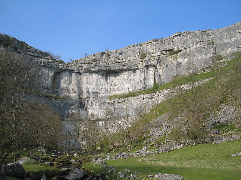
- Limestone pavements e.g. above Malham Cove - Dry valleys e.g. The Dry Valley of Watlowes - Gorges - Caves e.g. Ingleborough Caves Human activity
Human impacts on the landscape
Sources: BBC (2014) BBC Bitesize: GCSE Geography. Rock types in the British Isles. [Accessed on 11/08/15] Available from: http://www.bbc.co.uk/schools/gcsebitesize/geography/rock_landscapes/rock_types_rev2.shtml Starter Show a short clip of Harry Potter and the Deathly Hallows. Ask if they can name the limestone features shown and if they know where it was filmed. (On the limestone pavement at the top of Malham Cove). Main activities Students are shown a selection of photos of different limestone features in the Yorkshire Dales, they have to name the feature and describe how they were formed. Students are then given an OS map of the area and have to identify these formations and give correct grid references. Brainstorm the human uses of the area, using a collage of photos if necessary. Discuss as a class what impact these activities have on the physical landscape. Show students this clip of the BBC's 'The Trip' with Steve Coogan visiting Malham Cove. After watching, ask students to imagine they are the Malham Cove know-it-all, and write an information leaflet for visitors to the Yorkshire Dales, recommending places to visit and explaining the characteristics and formation of the landscape, as well as suggesting recreational activities in the are. This could be done for homework so that students could make a proper leaflet with maps, photos and diagrams. Plenary Give students a card from a pack of cards. I draw a card out of another pack and the student with the corresponding card has to tell me one thing they've learned about the Yorkshire Dales today. In this lesson I look at the characteristics, formation and human uses of granite landscapes using Dartmoor as a case study of a granite landscape. Case study: Dartmoor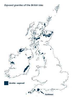 Dartmoor National Park Authority (2005) Geology and Landforms Factsheet http://www.dartmoor.gov.uk/__ data/assets/pdf_file/0019/41266/lab-geology.pdf Dartmoor National Park Authority (2005) Geology and Landforms Factsheet http://www.dartmoor.gov.uk/__ data/assets/pdf_file/0019/41266/lab-geology.pdf Characteristics
Human activity
Human impacts on the landscape
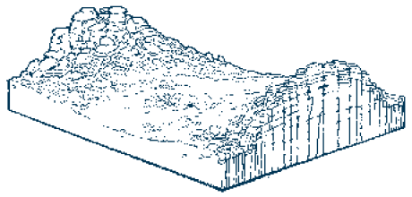
Sources: Dartmoor National Park Authority (2005) Geology and Landforms Factsheet. [Accessed 11/08/15) Available from: http://www.dartmoor.gov.uk/__data/assets/pdf_file/0019/41266/lab-geology.pdf BBC (2014) BBC Bitesize. Geography: Rock types in the British Isles. [Accessed 11/08/15] Available from: http://www.bbc.co.uk/schools/gcsebitesize/geography/rock_landscapes/rock_/types_rev1.shtml Coordination Group Publications Ltd. (CGP) (2010) GCSE Geography: The Revision Guide. CGP Devon County Council (no date) Devon Geology Guide: Dartmoor Granite. [Accessed 11/08/15] Available from: http://www.devon.gov.uk/geo-dartmoorgranite.pdf Dartmoor National Park Authority, Devon County Council, Peter Keene (2001) The Evolution of a Dartmoor Landscape: exploring Burrator [Accessed 11/08/15] Available from: http://www.dartmoor.gov.uk/__data/assets/pdf_file/0017/41039/au-burrator.pdf Starter I would set the context of the lesson with this video Dramatic Dartmoor (Dartmoor National Park Authority, 2014) showing views of Dartmoor National Park While they watch the video, I would ask them to answer the following questions: 1. What words would you use to describe the landscape? Suggested answers: barren, wild, empty, dramatic, rocky, craggy 2. What do you notice about the rock formations called tors? Suggested answers: rock, shattered, pointy, jagged, on top of hills 3. What other landforms can you see? valleys, rivers 4. What is the vegetation like? moor, low vegetation, grass, scrub, some forest, heather 5. What human uses of the landscape can you see? cycling, reservoir, dam, prehistoric stone circles, villages, church, farming, sheep farming, park ranger, tourists, walkers, climbers 6. Would you want to visit Dartmoor? After watching, students compare answers in pairs and feedback to the class. Main activities I would introduce the case study, showing the location of Dartmoor with the map shown above. I would elicit how we describe its location, so students practice describing the location as they would do in an exam i.e. Dartmoor is located in Devon in south west England. Next, we look at the geology of the area. I elicit what rock type granite is and what they remember about the formation and characteristics of igneous rocks. Tell students that Dartmoor is situated on a batholith, and elicit if they remember what a batholith is. I would show students a photograph of a tor and ask them to discuss in pairs how they think it was formed. I would then give them the following steps unnumbered and mixed up and ask them to put them in order. 1. Millions of years ago, the area was covered in tropical rainforests. 2. Vertical and horizontal joints, of varied density, formed in the granite. 3. Tropical rainwater ran down into the rock and along these joints, eating away at them. 4. Weathering is concentrated where joints are most densely packed. 5. Weathered rock is stripped away by erosion. 6. Through weathering the joints are widened. 8. The blocks of rock where the joints are widely spread leave blocks of stacked rock. 9. Frost action may further weather the joints - emphasizing the effects. 10. The unweathered sections form tors. As a class we look at these diagrams (see below) and feedback on the correct sequence. Students then get a worksheet with the correct process and diagrams on so they have a correct copy.
Students could then learn more about the case study from factsheets, either those on the Dartmoor National Park Authority website here or written by the teacher. Each group would have a different focus, e.g. geology, vegetation, tourism, they make notes and then give a presentation to the class so that everyone has the information. Plenary Tell your partner three things you learnt about Dartmoor in today's lesson. I would expect GCSE students to have studied rock types and the rock cycle either in KS3 Geography or in their Science lessons, but it is important that they have a good understanding of it. The 2016 exam specifications focus on the characteristics and distribution of rock types and their influence on the physical landscape, rather than their formation. Starter To jog students' memories, I would place cards on the whiteboard or their desks with names of rock types, how they're formed, characteristics and examples with photos. Students match the cards into rock types in groups or pairs. Elicit answers as a class. Main activities This video is a fun, memorable way of looking at rock formation. I particularly liked the demonstration of the changes in rock type using jelly beans. Students take notes during the video and complete a rock cycle diagram. Now they understand the rock types and the rock cycle, students write the "Autobiography of a Rock". I assign each student with a rock type (so they can't copy their neighbour's work) and they tell their story of being a rock changing into each type of rock. Plenary A short quiz to test what they've learnt. For example: I formed from magma cooling at the surface. What type of rock am I? I used to be limestone but now I'm marble. How did I change? I have fossils of seashells in me. What type of rock am I? Homework Students could research the everyday uses of these rock types. Although uses of rocks isn't part of the exam specification, it could link into looking at human uses of the landscape, such as quarrying.  By Captain Blood (Own work) CC-BY-SA-3.0 via Wikimedia Commons https://en.wikipedia.org/wiki/ Geography_of_the_United_Kingdom By Captain Blood (Own work) CC-BY-SA-3.0 via Wikimedia Commons https://en.wikipedia.org/wiki/ Geography_of_the_United_Kingdom I would use the first class of this module to introduce the topic and set the context. Here are some ideas to use in the classroom.
Starter By GCSE level, I would expect students to have a relatively good understanding of the geography of the UK. To check and consolidate what they know, and to start the topic off on a fun note, I could do a short UK Geography quiz as a starter. This could include general information such as size, highest point, most southerly/northerly point, locations of cities and rivers. The Telegraph Travel website has a quiz, "How well do you know Britain's landscapes?", which is very tricky! But this multiple choice format with a photo could be used to create a quiz of UK landscapes. This quiz can be found at: http://www.telegraph.co.uk/travel/destinations/europe/uk/10803513/Quiz-how-well-do-you-know-Britains-landscapes.html Main activities I show students famous physical landscapes, for example the White Cliffs of Dover, Ben Nevis, the Lake District or those included in the RGS lesson plan resources (see link below). Students could work in groups to name and guess the location of the landscapes, perhaps by sticking them on a map of the UK. I then show a relief map of the UK (such as that shown right), and give students a series of true or false statements e.g. there is no land above 300m, most low-lying land less than 50m is in the north. They then write a paragraph describing the relief of the UK. Elicit as a class how we can divide the country into lowland and upland.(based on Royal Geographical Society lesson plan: Limestone landscapes and their uses. Available from: http://www.rgs.org/NR/rdonlyres/FA6D07B9-2FBE-437E-9245-F67DDD35755D/0/Limestonelandscapesandtheiruses.pdf) Then the class brainstorms characteristics of these areas, with prompts such as climate, habitat type, altitude, geology, before filling out a factsheet, possibly by categorising given descriptions or features into columns. Then students categorise the original landscape photos as examples of upland or lowland landscapes. Finally, using the same photos I ask students if they can see any evidence of human activity or if they can think of possible human use of the landscape e.g. agriculture, tourism, forestry, and how this would impact the landscape. Plenary Students write three facts they've learned about upland areas and three for lowland areas. Elicit a selection of answers from students. Homework Students design a tour of some of the UK's famous landscapes for visitors to the country. This allows them to practise describing locations geographically, and encourages them to describe the physical characteristics and visitor attractions of the landscape. This idea is based on an interesting lesson plan from the Royal Geographical Society called "Introducing Britain's Geography", which is aimed at Year 7 or 8 students. The lesson plan and resources can be found here: http://www.rgs.org/OurWork/Engaging+wider+audiences/Britain+from+the+Air/Educational+Resources/Secondary+resources+-+Geography.htm Another idea for a homework activity is to ask students to write their own short UK Geography quiz, with answers. A longer-term project, for example over a holiday period, could ask students to create a 3D relief map of the UK or of a particular landscape. I saw this in a class during my school observations. Students were asked to create a 3D colour-coded model based on an OS map. Their results were very impressive and the students seemed to have enjoyed the task. |
AuthorMy name is Heather and I am going to begin my SCITT course to train as a Geography teacher. ArchivesCategories
All
|
 RSS Feed
